
 Aberdare National Park
The Aberdares are part of Kenya’s central highlands, running roughly north south between Nairobi and Thomsons Falls with a range of almost 13,000 ft. The topography is diverse with deep ravines that give way to gentler valleys separated by steep hills and rocky outcrops. The park is an important water catchment area providing water to the Tana and Athi rivers and part of Central Rift and Northern drainage basins. The climate is wet and moist. The park is surrounded by a predominantly indigenous forest, whose management is under an MoU between KWS and the Forest Department.
Animal life is most abundant in the forest zone. Large mammals are represented by elephants, buffalo, bongo and black rhino among others. Carnivores include lion and leopard, whereas primates are represented by baboon, black and white colobus and sykes monkeys. The park is rich in bird life with over 250 species recorded. The Jackson’s Francolin is endemic.
Amboseli National Park
 Amboseli National Park is located on the border with Tanzania, Kajiado District, South Kenya; Covers 392km2 Amboseli lies immediately North West of Mt. Kilimanjaro, on the border with Tanzania. The Park covers 392 km2, and forms part of the much larger 3,000 Km2 Amboseli ecosystem. Large concentrations of wildlife occur here in the dry season, making Amboseli a popular tourist destination. It is surrounded by 6 communally owned group ranches. The National Park embodies 5 main wildlife habitats (open plains, acacia woodland, rocky thorn bush country, swamps and marshland) and covers part of a pleistocene lake basin, now dry. Within this basin is a temporary lake, Lake Amboseli, that floods during years of heavy rainfall. Amboseli is famous for its big game and its great scenic beauty – the landscape is dominated by Mt. Kilimanjaro. The climate is mainly hot and dry. Amboseli is in the rain shadow of Mt. Kilimanjaro. The maximum average temperature of the warmest month is 33°C during the day, while that of the coldest is 27-28°C.
Accessibility By road, the main road into the Park is from Nairobi via Namanga (240 km) on the Nairobi – Arusha Road, via Meshanani Gate. The road is tarmac upto Namanga but is badly corrugated and potholed in places from Namanga to Meshanani Gate (75km). The other road is via Emali (228 km) on the Nairobi – Mombasa Road. The road is tarmac up to Emali and murram from Emali to Remito Gate (64 km). Access from Mombasa is mainly through Tsavo West via Kimana (Olkelunyiet) Gate.
The park has a single airstrip for light aircraft at Empusel gate. Other airstrips exist at Kilimanjaro Buffalo lodge and Namanga town.
Major Attractions
- Mt. Kilimanjaro
- Mt. Meru
- Observation Hill which allows an overall view of the whole park especially the swamps and elephants,
- Contemporary Maasai culture and indigenous lifestyle
Lodges: Oltukai Lodge; Amboseli Serena Lodge; Kimana Lodge; Tortilis Tented Lodge.
Campsites: Nairushari Special; Olgulului Public Campsite; Abercrombie & Kent Tented Camp; Ker & Downy Tented Camp; Chyulu Tented Camp; Kimbla Campsite; Cottar’s Tented Camp; Leopard Tented Camp; Tortilis Tented Camp. For more information, please visit the Kenya Wildlife Service website www.kws.org
 Buffalo Springs National Reserve
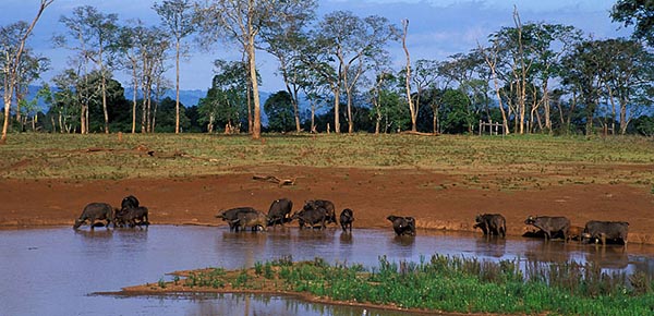
Buffalo Springs Reserve covers 194 km2 on the southern bank of the Uaso Nyiro river. The reserve has unique landscapes of rounded and rugged hills and undulating plains.
Hot and Dry, the vegetation is mainly wooded and bushy grassland, riverine forest and swamps. With over 50 species of large mammals, the parks’ bird life is diverse with Buffalo Springs having a record of 365 species.
Central Island
The park is within Lake Turkana. Central Island is only 5 km2 Central Island has three scenic crater lakes i.e. Crocodile, Flamingo and Tilapia. The climate is hot and dry. Turtles are found in the lake waters. The island is an important breeding ground for crocodiles and water birds.
Chale Island
This small island, south of Galu Beach, is beautiful with a lovely natural sandy bay, dramatic rock formations and a great variety of indigenous trees.
Chyulu Hills
The Chyulu Hills are a beautiful rolling ridge of volcanic hills in the south of Kenya. On the eastern side of the range is the black Shaitani Lava flow, a ridge of lava rock formed whenthe Chyulus were formed. This lava flow is near the Chyulu gate of Tsavo West National Park. The hills consist of beautiful valleys and peaks with views in all directions, Mount Kilimanjaro can be visible. Rain on the hills gives rise to underground rivers. Wildlife encompasses giraffe, elephant, loin, monkeys, buffalo and crocodile in the springs at the bottom of the hills.
Climate is hot and dry.
Hell’s Gate National Park
 Hell’s Gate National Park is particularly impressive with soaring red cliffs, isolated volcanic plugs, spreading grasslands dotted with game and a deep gorge where visitors can walk. Fischer’s Tower is a challenging rock climb. This park is excellent for succulents, birds of prey and other bird species.There is a geothermal project at the far end of the parkHell’s Gate National Park covers an area of 68.25 km2 is situated in the environs of Lake Naivasha about 90 km from Nairobi. The park is situated 14 km after the turnoff from the old Nairobi-Naivasha highway. The park is characterised by diverse topography and geological scenery. It is an important home of the lammergeyer The climate is warm and dry and the vegetation is Mainly grasslands and shrublands with the latter being dominated by Leleshwa and several species of acacia. The gorge and cliffs and breeding sites for several species of raptors and swifts. 103 species of birds have been recorded in the park.
 Lake Bogoria National Reserve
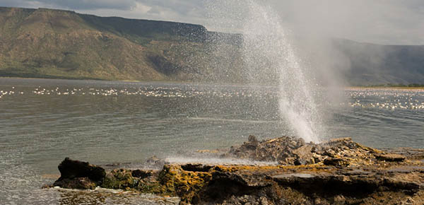
Lake Bogoria lies just south of Lake Baringo but contrasts sharply with Baringo’s green and lush surroundings. This soda lake, with its shores of hot springs, boiling geysers and steam jets, stark evidence of the volcanic origins of the Rift Valley, lies hidden behind ridge after ridge of barren stony scrubland. Although primarily scenic, Bogoria is by no means devoid of wildlife. Birds are plentiful and, at times, when the waters of Lake Nakuru are low, thousands of flamingo make this their home. On the north-eastern shore the elusive Greater Kudu can be found. Lake Bogoria National Reserve is owned and managed by Baringo County Council with assistance from KWS. The reserve covers 114 km2 and is famous for spectacular hotsprings and geysers. To the east of the reserve is the scenic Siracho escarpment that descends steeply to the lake shore.
Hot and dry, most of the reserve is occupied by the lake and the remaining areas are covered by bushed grasslands except the lake’s south shore which has an acacia-ficus woodland. The northern shore has a papyrus swamp.
The reserve is unique because of its herd of the rare Greater Kudu. There are also buffalos, zebras, impalas, dik diks and many small mammals. Bogoria is also an area of significant ornithological interest with 135 species of birds recorded. Like in Nakuru, the alkaline lake waters allow growth of blue-green algae that periodically attracts thousands of flamingoes.
Lake Naivasha
 The highest and purest of the Great Rift Valley lakes, Lake Naivasha lies approximately 80 kms west of Nairobi on the floor of the Rift. The Lake shores are lined with fertile and flourishing horticultural farms and thousands of yellow barked acacias. Naivasha is home to more than 340 species of birds, has a resident population of hippo and small herds of plains game are found all around the shores. Bird and game viewing is by boat or on foot. The lakeshore was, for many years, the home of the late authoress Joy Adamson and it was here that she first raised Elsa, the lioness. Mount Longonot, an extinct volcano, lies just east of the Lake and Hell’s Gate National Park south east, with its challenging rock climbs, where game abounds and birdlife includes the rarest of Kenya’s vulture population, the Lammergeyer, which nests on the cliffs.
 Lake Nakuru
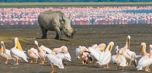
The park is located in Central Kenya, 140km north-west of Nairobi, in Nakuru District of the Rift Valley Province. It covers an area of 188 km2. Lake Nakuru is a very shallow strongly alkaline lake 62 km2 in extent. It is set in a picturesque landscape of surrounding woodland and grassland next to Nakuru town. The landscape includes areas of marsh and grasslands alternating with rocky cliffs and outcrops, stretches of acacia woodland and rocky hillsides covered with a Euphorbia forest on the eastern perimeter. Lake Nakuru was first gazetted as a bird sanctuary in 1960 and upgraded to National Park status in 1968. A northern extension was added to the park in 1974 and the lake was designated as a Ramsar site in 1990. The foundation of the parks food chains is the cyanophyte spirulina platensis which can support huge numbers of lesser flamingo.
Climate ranges from Cold, Hot and Humid, Hot and Dry. Annual rainfall is 965mm
Accessibility
The park has a tarmac road connection with Nairobi, a distance of 156 km north west of Nairobi on the main A104 road. The most commonly used route into the park is via the main gate, 4 km from Nakuru Town Centre. It is also possible to enter the park from the main Nairobi Nakuru road at Lanet Gate. The Nderit Gate is used by people accessing the park from Masai Mara or Elementaita. The Naishi airstrip services the park for tourists.
Major Attractions
- Flamingo (Greater and Lesser) and other water birds including a variety of terrestrial birds numbering about 450 species in total.
- Mammals: 56 different species including white rhinos.
- View-points: Lion hill, Baboon cliff and Out of Africa
- Hills: Enasoit, Honeymoon, Lion hill ridge etc.
- Waterfalls: Makalia
- Unique vegetation: About 550 different plant species including the unique and biggest euphorbia forest in Africa, Picturesque landscape and yellow acacia woodlands.
Bandas: Naishi bandas
Lodges: Lake Nakuru lodge & Sarova Lion Hill Lodge.
Special Campsites: Naishi, Chui, Rhino, Soysambu, Nyati, Nyuki and reedbuck.
Public Campsites: Makalia and Bacpakers.
Activities Game viewing, bird watching
Common Vegetation The vegetation is mainly wooded and bushy grassland with a wide ecological diversity and characteristic habitats that range from the lake waters to the escarpment and ridges.The normally water-covered surface of the lake occupies about a third of the park. The lake water supports a dense bloom of the blue-green Cyanophyte Spirulinaplatensisfrom which it derives its colour and which is the major food source for the flamingo.The lake is fringed by alkaline swamps with areas of sedge,Cyprus laevigatus and typha marsh along the river inflows and springs. The surrounding areas support a dry transitional savanna with lake margin grasslands of Sporobolus spicatus salt grass moving into grasslands of Hyparrhenia hirta and rhodes grass Chloris gayana in the lower areas. More elevated areas have dry forest with Acacia xanthophloea, olive Olea hochstetteri andCroton dichogamus; Euphorbia candelabrum forest; and bushland dominated by the composites, Mulelechwa Tarchonanthuscamphoratus and Psiadia arabica. For more information please visit the Kenya Wildlife Service Website www.kws.org
Masai Mara
 The Masai Mara is considered by many to be one of Kenya’s finest National Reserves. The rolling grasslands offer ideal game viewing and photographic opportunities and the grassy plains are broken by rocky outcrops which are favourite midday resting places for lion, for which the Mara is famous. Some of the other animals which can be seen in and around this 700 square mile conservation area include elephant, black rhino, buffalo, leopard, cheetah, wildebeest, zebra, and gazelle. Hippo and crocodile abound in the muddy brown waters of the rivers which traverse this Reserve. One of the Mara’s main attractions each year is the astonishing spectacle of the annual migration of up to two million wildebeest, thousands of zebra and an escort of carnivores from the Serengeti plains, following the rains and succulent new grass. A costly trek as many of the lame, laggard and sick will fall prey to the ravening pack of predators and many more will die in the swirling flood waters trying to cross the Mara River. Once the rains have ended and the grass begins to wither the wildebeest turn south and head back to the Serengeti and beyond. The reserve with an area of 1510 km2 forms the northern part of the Serengeti-Mara ecosystem and is famous for vast assemblages and migration of plains game and their associated predators. The parks southern boundary is contiguous with Tanzania’s Serengeti National park.
With the hot and dry climate, the landscape is characterized by scenic rolling grassland plains, rounded hills and grooves of woodlands. Green riverine forests and bush thickets are found along the Mara river.
Elephant, black rhino, buffalo, plains zebra, hartebeest, wildebeest and other herbivores and all the big cats are also found in Mara. The rivers are home of crocodiles and hippos.
 Meru National Park
Meru National Park is located East-north-east of Mount Kenya in Meru District of Eastern Province, covering 870km2.Meru is a savanna National Park, 35km east of Maua town in the north eastern lowlands below the Nyambeni hills. Meru is part of a complex of protected areas along the Tana river that includes the adjacent Bisanadi and Mwingi National Reserves (to the east and south respectively), Kora national park and Rahole national reserve. The wetter North Western sector is hilly, with rich volcanic soils. The land flattens towards the East, where grey alluvial volcanic soils appear. The area is crossed by numerous permanent streams, draining from the Nyambenes and flowing in parallel between tounges of lava, south eastwards towards the Tana River. As well as the many streams that cross it, the park is bounded by three large rivers: the Tana to the South, the Ura to the South West and the Rojeweru to the East. There are several prominent inselbergs of basement rock, notably Mughwango and Leopard rock. Rainfall is 635-762mm in the west and 305-356mm in the east.
Accessibility
Access from Nairobi (348 kms) is via Nyeri-Nanyuki-Meru or via Embu all weather roads. Access into the park from Maua to Murders Gate (35 km) and 348 km from Nairobi. The other access is via Embu to Ura Gate (120 km), 290 km from Nairobi- inaccessible at the momentMain airstrip at Kina, Mulika next to Meru Mulika Lodge and Elsa’s Kopje airstrip
MAJOR ATTRACTIONS
- Former home of Joy and George Adamson and Elsa the lioness
- Views of Mt Kenya,
- Rivers and riverine habitats,
- Tana river and
- Adamson’s Falls.
FACILITIES
Special Campsites Kampi Baridi, Kitanga, Makutano, Rojoweru, Mugunga, Ken Mare, Bwatherongi and Kanjoo.
ACTIVITIES
Game viewing.
COMMON VEGETATION
Most of the park is covered by bush, thornbush and wooded grassland of varying densities with Combretum prevailing in the north and Commiphora in the south. In the extreme north there is a small remnant outliner of rain forest, the Ngaia forest.The vegetation on the ridges is Combretum wooded grassland, dominated by Combretumapiculatum. This grades into acacia wooded grassland to the east with Acacia tortilis andAcacia senegal on the rocky ridges, in riverine thickets and dotted over open country. To the west the Combretum merges into Terminalia wooded grasslands.On the plainsSehima nervosa, Chlorisgayana, Chlorisroxburghiana, and other species of Pennisetumare the dominant grasses.Dense riverine forests of doum and raffia palms Hyphaene andRaphia spp. grow along the watercourses and in the swamps near the rivers. Along the Tana river is found the Tana river poplar, Populus ilicifolia. Other riverine trees includePhoenixreclinata, Ficus sycomorus, Newtoniahildebrandtii, Acacia elatior and Acaciarobusta. The red-flowered Parasitic Loranthus grows on the branches of Acacia reficienstrees along the rivers. There are numerous riverine swamps with sedges Cyprus sp. and grasses Echinochloahaplacelada and Pennisetum mezianum. For more information, please visit the Kenya Wildlife Service website www.kws.org
Mount Kenya National Park
 Mt. Kenya lies about 140 km North, North-East of Nairobi with its Northern flanks across the Equator. The mountain has two main peaks – Batian (5200m) and Nelion (5188m). The mountains slopes are cloaked in forest, bamboo, scrub and moorland giving way on the high central peaks to rock, ice and snow. Mt. Kenya is an important water catchment area, supplying the Tana and Northern Ewaso Ngiro systems. The park, which was inscribed by UNESCO as a World Heritage Site in 1997 and is also a Biosphere Reserve, covers 715 km2, and includes the Peaks consisting of all the ground above 3200m with two small salients extending lower down to 2450m along the Sirimon and Naro Moru tracks. Surrounding the park is Mount Kenya National Reserve with an area of approximately 2095 km2.Climate, flora and fauna on Mt. Kenya varies with altitude.
Accessibility175 kms from Nairobi, the park can be reached on Nanyuki-Isiolo road via Sirimon Track or Nyeri-Nanyuki road near Naro Moru. The park is also reachable via Chogoria on the Embu – Meru road, about 150km north of Nairobi.The closest commercial airstrip to the park is at Nanyuki.
Major AttractionsPristine wilderness, lakes, tarns, glaciers and peaks of great beauty, geological variety, forest, mineral springs, rare and endangered species of animals, High altitude adapted plains game, Unique montane and alpine vegetation with 11 species of endemic plants.
Facilities Huts: Liki North Hut; Minto’s Hut; Austrian Hut; Mackinders Hut (managed by Naro Moru Lodge); Judmare Hut; Shiptons Hut (managed by Mountain Rock Hotel).Bandas: Sirimon Bandas, Batian Guest House.
Lodges: Mountain Lodge (Serena Hotels); Rutundu Fishes Lodge (book through Lets Go Travel)
ACTIVITIES
Mountain climbing, game viewing.
COMMON VEGETATION: This varies with altitude and rainfall, and there is a rich alpine and sub-alpine flora.Between 1200m and 1850m, the vegetation is mainly dry upland forest comprising of Croton associations. Juniperus procera and Podocarpus spp. are predominant in the drier parts of the lower zone (below 2,500m), with rainfall between 875 and 1400mm (Naro Moru and Sirimon tracks on the western slopes). In wetter areas (over 2200mm/year) in the south-west and north-east, Cassipourea malosana predominates.Higher altitudes (2,500-3,000m with rainfall over 2000mm/year) are dominated by a dense belt of bambooArundinaria alpina on south-eastern slopes, and a mosaic of bamboo and Podocarpusmilanjianus with bamboo at intermediate elevations (2,600-2,800m), and Podocarpus at higher and lower elevations (2,800-3,000m) and (2,500-2,600m).Towards the west and north of the mountain, bamboo becomes progressively smaller and less dominant.
There are also areas in zones of maximum rainfall 2,000-3,500m with up to 2,400mm/year, where Hagenia abyssinica with Hagenia revolutum predominate.Above 3,000m, cold (low temperatures) become a more important factor, tree stature declines, and Podocarpus is replaced by Hypericum spp. A more open canopy here results in a more developed understorey. Many of the trees are festooned with mosses. Grassy glades are common especially on ridges. High altitude heath between 3,000m and 3,500m is characterised by shrubs with small leaves like African sage, Protea and Helicrysum.The lower alpine or moorland zone (3,400-3,800m) is characterized by high rainfall, a thick humus layer, low topographic diversity, and low species richness. Tussock grasses Festuca pilgeri, and sedges Carex spp. predominate. Between the tussocks there are Alchemilla cyclophylla, Alchemillajohnstonii, and Geranium vagans.
Above the 3500m contour is the Afro-alpine zone, a moorland characterised by tussock grasses, senecios and lobelias.The upper alpinezone (3,800-4,500m) is more topographically diverse, and contains a more varied flora. Many of the species here are bizarre, especially the giant rosette plants Lobelia telekii and Lobelia keniensis, Seneciokeniodendron and Carduus spp.. Senecio brassica is found in both the lower and upper alpine zone.
There are a variety of grasses on well-drained ground and along the streams and river banks such as megaphytic Senecio battescombei and Helichrysum kilimanjari. Continuous vegetation stops at about 4,500m although isolated vascular plants have been found at over 5,000m. There are 13 species endemic to Mount Kenya listed in Hedberg, (1951).
For more information, please visit the Kenya Wildlife Service website www.kws.org
Nairobi National Park
Located only about 7 km from the city centre, the park is easily accessible on tarmac roads, mainly through Langata Road.The 117 km2 Nairobi National Park is unique by being the only protected area in the world with a variety of animals and birds close to a capital city. As expected, the park is a principal attraction for visitors to Nairobi. The park also serves many residents and citizens living in the city and has a diversity of environments with characteristic fauna and flora. Open grass plains with scattered acacia bush are predominant. The western side has a highland dry forest and a permanent river with a riverine forest in the south. In addition, there are stretches of broken bush country and deep, rocky valleys and gorges with scrub and long grass. Man-made dams have also added a further habitat, favourable to certain species of birds and other aquatic biota(life forms). The dams also attract water dependent herbivores during the dry season.The park has a rich/diverse birdlife with 400 species recorded. However all species are not always present and some are seasonal. Northern migrants pass through the park primarily during late March through April. Nairobi National Park is one of the most successful of Kenya’s rhino sanctuaries that is already generating a stock for reintroduction in the species former range and other upcoming sanctuaries. Due to this success, it is one of the few parks where a visitor can be certain of seeing a black rhino in its natural habitat. To the south of the park is the Athi-Kapiti Plains and Kitengela Migration and dispersal area. These are vital areas for herbivores dispersal during the rains and concentrate in the park in the dry season.
MAJOR ATTRACTIONS
- Annual wildebeest and zebra migration in July/August
- Black rhinoceros
- Diverse birdlife
- Large predators- lion, leopard, hyena and cheetah.
- Aggregations of large herbivores- eland, buffalo, zebra and wildebeest
- Ivory Burning Site Monument
- Walking trails at hippo pools
- Nairobi Safari Walk & the Orphanage.
- Spacious accomodating picnic sites
FACILITIES
There are no accommodation facilities in the park. But a wide range of well developed accommodation facilities are available in the city. Further, there is also the Masai Safari Lodge near the park.
Picnic Sites:
- Impala Observation Tower;
- Ivory Burning Site;
- King Fisher Gorge;
- Leopard Cliffs;
- Mokoiyet;
- Hippo Pool;
Other attractions
- Lone Tree
- Directors tree planting site
Nature Trails:
The park has one nature trail at the Hippo Pool
COMMON VEGETATION
The vegetation is primarily dry savanna, open grass plains with scattered acacia bushes. The park also has a permanent river with a riverine forest. The western upland areas has an upland dry forest with stands of Olea africana and Croton dichogamus/Brachylaena hutchinsii and calodendrum. The lower slopes are a grassland composed of such species as: Themeda, Cyprus, Digitaria, and Cynodon with scattered yellow-barked acacia, Acacia xanthophloea. In addition there are stretches of broken bush country and deep rocky valleys and gorges with scrub and long grass.There is gallery forest in the valleys, predominantly Acacia spp., and Euphobia candelabrum. Other tree species include Apodytes dimidiata, Canthiumschimperanum, Elaeodendronbuchananii,Newtonia sp., Ficuseriocarpa, Aspiliamossambicensis, and Rhus natalensis. Several plants growing on the rocky hillsides are unique to the Nairobi area includingEuphobia brevitorta, Drimiacalcarata, Murdanniaclarkeana and the crassula sp.
For more information, please visit the Kenya Wildlife Service website www.kws.org
Samburu National Reserve
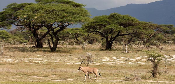
 Samburu National Reserve is situated in the hot and arid fringes of Kenya’s vast Northern Frontier District. The area is home to the Samburu tribe, pastoral relatives of the Masai. The landscape is rugged and dramatic – against a backdrop of volcanic mountains, gaunt hills and withered scrub tree punctuate the sparse and dry terrain with clusters of the incredibly hardy desert rose providing the occasional flash of vivid colour. The Ewaso Nyiro river, lifeline of the area, runs along the southern boundary dividing Samburu from Buffalo Springs Reserve. Crocodile and hippo share the river with the many small herds of elephant which bathe and frolic in the muddy brown waters during the heat of the day before returning later to browse on the lush vegetation of the riverine forest. Buffalo, lion, leopard, cheetah and plains game may also be seen but a special feature of this Reserve are the various species of game unique to these northern parks – Beisa oryx, the long necked gerenuk, Grevy’s zebra, reticulated giraffe and the blue shanked Somali ostrich.Samburu Reserve covers an area of 104 km2 on the northern bank of Uaso Nyiro river. The reserve has a unique landscapes of rounded and rugged hills and undulating plains.
Hot and Dry, mainly wooded and bushy grassland, riverine forest and swamps.
Over 50 species of large mammals including reticulated giraffe, grevys zebra, elephant oryx, somali ostrich, hippo, crocodiles, gemuk, buffalo, lion, leopard, cheetah and hyena. Large flocks of helmeted and vulturine guinea fowls are a common attraction.
Shaba National Reserve
Shaba National Reserve is situated in the hot and arid fringes of Kenya’s vast Northern Frontier District and lies to the east of Buffalo Springs Reserve, just across the Great North Road. The Reserve takes it’s name from a cone of volcanic rock and evidence of the intensity of it’s volcanic upheaval is demonstrated by the formidable lava flow which the traveller has to cross to reach this remote wilderness. Shaba’s northern border is marked by the flow of the Ewaso Nyiro River on it’s way to the Lorian Swamp, it’s banks fringed by riverine forest and clusters of doum palms. Many small hills and rocky kopjes punctuate the rugged and dry terrain south of the river. Shaba is home to the many different species of game found in Samburu and Buffalo Springs Reserves with small herds of elephant and other plain game moving freely throughout these three reserves and the surrounding wilderness.Shaba Reserve is 130 km2 on the southern back of the Uaso Nyiro river to the East of Buffalo Springs Reserve. The reserve has a unique landscapes of rounded and rugged hills and undulating plains.
Mainly wooded and bushy grassland, riverine forest and swamps, with over 50 species of large mammals including reticulated giraffe, grevys zebra, elephant oryx, somali ostrich, hippo, crocodiles, gemuk, buffalo, lion, leopard, cheetah and hyena.
Large flocks of helmeted and vulturine guinea fowls are a common attraction.
Tsavo East National Park
It is the largest Park in Kenya with an area of 21,812 Km2 Tsavo National Park was divided into East and West for administrative purposes. The two Parks are divided by Nairobi–Mombasa railway /road.
Scenic features Tsavo East is a very popular Park as is indicated by the high number of tourists. Some of the attractive scenic features include:
- large herds of elephants and other wildlife.
- it is easily accessible by road, air (light aircraft) and railway. the Park is a “catchments” for coast resorts’ visitors.
- popular legend of Tsavo “The Man-eaters of Tsavo”.
- Yatta plateau – It is about 290Km long and is one of the worlds longest lava flows.
- Lugards Falls on the Galana river – This is not a true falls but a series of rapids. Visitors can walk down to the river to view the rapids.
- Mudanda rock – This is a long rock outcrop that is about 1.6Km long. There is a dam at the base. Animals can be seen drinking. Visitors can walk along the rock and enjoy a cool breeze as well as view wildlife at the base.
- Aruba Dam – was built in 1952 across the Voi river. The dam attracts many animals and water birds can be seen at this dam.
- Tsavo/Athi rivers confluence – when the two rivers join they form the Galana river.
- Elephants, Rhinos, Hirola (Hunters Hartebeest).
Accessibility
- From Nairobi via Voi through the Voi gate or Manyani gate.
- Similarly, from Mombasa via Bachuma gate.
- From Malindi, via Sala gate. This road was recently graded and is attracting many visitors from North Coast.There are six airstrips in the southern part of the park and thirteen in the Northern part.
- There are no scheduled flights to the Park but chartered light planes can be used.
For more information, please visit the Kenya Wildlife Service Website www.kws.org
Tsavo West National Park
 Located in South Eastern Kenya, inland from Mombasa, and the altitude ranges between 200 – 1000m. The park is a vast expanse of savanna stretching from Mtito Andei, along the Mombasa-Nairobi road and south to the Tanzanian border. The North Eastern boundary along the Highway adjoins Tsavo East National Park, but Tsavo West has a more varied topography and a more diverse array of habitats than its neighbour. Tsavo West National Park covers 7065 km2, approximately 30% of Kenya’s area under parks, and contains a diversity of habitats, wildlife and a mountainous scenic landscape. The park’s habitats include open plains alternating with Savannah bush and semi desert scrub, acacia woodlands; rocky ridges and outcrops and more extensive ranges and isolated hills; belts of riverine vegetation; palm thickets and on the Chyulu hills, mountain forest.There are numerous rocky outcrops and ridges and part of the park, towards the Chyulu Hills, is of recent volcanic origin with lava flows and ash cones including the Shetani lava flow, an example of a recent volacano. In the far south western corner on the Kenya Tanzania border is Lake Jipe, part of which is in the park. This very attractive lake is fed by runoff from Mt. Kilimanjaro and the North Pare mountains.At Mzima Springs, in the North of the park, water that has filtered underground from the Chyulu Hills gushes from below a lava ridge into a series of clear pools.Temperature ranges from 20 – 30º C and rainfall from 200mm – 700mm. Two ran seasons: Long rains – March/April & Short rains – Nov/December.
Accessibility
The main access routes are through Chyulu Gate from Amboseli and Mtito Andei Gate from Nairobi (240 km) and Mombasa. Visitors from Mombasa also use Tsavo Gate near Manyani. The park can also be reached via Taveta-Voi road through Maktau, Ziwani and Jipe gates.
Airstrips: Kamboyo, Kilaguni, Tsavo Gate, Jipe, Kasigau, Finch Hottons, Ziwani and Maktau airstrips are in good condition.
Major Attractions
Recent volcanoes, lava flows and caves with potential for geological and cave exploration, and hiking. Mzima Springs & underwater hippo watching, Ngulia Rhino Sanctuary, Lake Jipe, Mt. Kilimanjaro, elephant, rhino, diverse bird and plant species.
Lodges: Ngulia Lodge; Kilaguni Serena Lodge; Severin Safari Camp/Lodge; Finch Hattons.
Campsites: Lake Jipe (public); Kamboya (public); Royal Little (special); Simba (special); Kenge (special); Kudu (special).
Bandas: Lake Jipe; Kitani; Ngulia.
Picnic Sites: Poachers look out; Chaimu Crater; Shetani Lava Flow; Roaring Rocks; Mzima Springs; Visitor Information Centre Picnic Site.
COMMON VEGETATION
Most of the northern sector is Acacia commiphora bushland with scattered trees such as baobabs – Adansonia digitataand Delonix elata. In the Ngulia area, a range of craggy hills reaches around 1800m and is heavily wooded. The southern sector consists of open grassy plains. The permanent tsavo river runs through the northern part of the park with a fringe of riverine Acacia elatiorand Hyphaene compressa woodland. Lake Jipe is bordered by extensive beds to Typha and has large permanent swamps at its eastern and western ends. Mzima springs, is fringed by Raphia farinifera and Phoenixreclinata palms.
Visitor Activities Boat excursion at lake Jipe; Bird watching at lake Jipe; Annual bird ringing at Ngulia lodge; Hill and rock climbing at Chaimu and Ngulia Hills.
For more information please visit the Kenya Wildlife Service Website www.kws.org


